Polar Vortex – Why 200 Million Americans Should Prepare Now
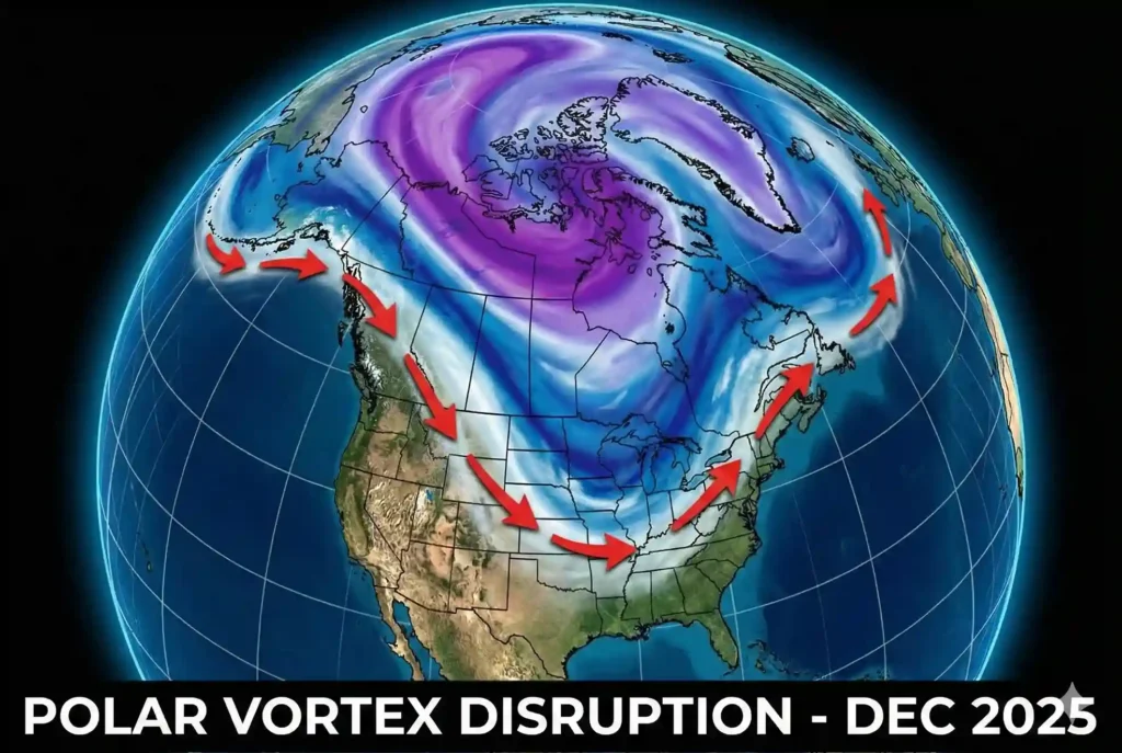
A major shift in the atmosphere has meteorologists sounding the alarm this week. As of Sunday, December 7, 2025, forecasts indicate that the “fence” keeping bitter Arctic air trapped at the North Pole is breaking down. This phenomenon, known as a Polar Vortex disruption, is set to unleash a punishing wave of freezing temperatures across the United States just as the holiday season peaks.
While winter cold is expected, this event is different. Data suggests a “Sudden Stratospheric Warming” event is occurring miles above the Earth, forcing the jet stream to buckle. The result? A direct pipeline of sub-zero air spilling from Siberia and Canada deep into the American heartland. From the Midwest to the Northeast, and potentially dipping into the South, nearly 200 million residents are in the path of this developing freeze.
This isn’t just about needing an extra coat. This level of cold threatens power grids, endangers travelers, and poses serious risks to home infrastructure like plumbing. If you thought the start of December was mild, brace yourself—the real winter is arriving, and it’s arriving fast.
5. Table of Contents
- What is Happening? The Science of the 2025 Polar Vortex
- Impact Map: Which States Are in the “Danger Zone”?
- The Timeline: When Will the Deep Freeze Hit?
- Essential Survival Guide: Home, Car, and Pets
- Frequently Asked Questions (FAQs)
- Conclusion: Stay Warm, Stay Safe
What is Happening? The Science of the 2025 Polar Vortex
To understand why this forecast is critical, we need to look at the mechanics of our atmosphere. The Polar Vortex is essentially a large area of low pressure and cold air surrounding both of the Earth’s poles. It always exists near the poles, but it weakens in summer and strengthens in winter.
The “Fence” Analogy
Think of the Polar Vortex as a spinning top or a fence. When it is strong and spinning fast, it keeps the super-cold air locked up tight in the Arctic circle. It acts as a barrier.
- Strong Vortex: Cold air stays North. The US stays relatively mild.
- Weak/Disrupted Vortex: The “fence” breaks. The top starts to wobble. This allows the frigid air to spill southward, like water over a dam.
Sudden Stratospheric Warming (SSW)
Right now, meteorologists are tracking a Sudden Stratospheric Warming event. This happens when temperatures in the stratosphere (about 20 miles up) spike rapidly. This heat “punches” the Polar Vortex, causing it to slow down or even split into two pieces.
- Current Status: The vortex is stretching.
- Result: The Jet Stream (the river of wind that steers our weather) is dipping aggressively south, opening the door for Arctic air to flood the continental US.
Key Fact: This is not “new” weather, but the intensity of the disruption in December 2025 is creating a setup similar to the historic freezes of 2014 and 2021.
Impact Map: Which States Are in the “Danger Zone”?
Not every state will feel the same intensity, but the reach of this Arctic blast is extensive. The cold front is expected to sweep from the Northern Plains across to the East Coast.


High Risk: Deep Freeze & Hazardous Winds
These areas should prepare for life-threatening wind chills and potential power outages due to demand spikes.
- The Upper Midwest: North Dakota, Minnesota, Wisconsin, Michigan.
- Forecast: Temperatures dropping to -20°F (actual air temp) with wind chills far lower.
- The Northeast: New York, Vermont, New Hampshire, Maine, Pennsylvania.
- Forecast: Flash freezing risks and heavy “lake effect” snow as cold air moves over warmer Great Lakes waters.
Moderate Risk: Icy Roads & Burst Pipes
These regions are less accustomed to extreme cold, making infrastructure vulnerability a major concern.
- The Ohio Valley: Ohio, Indiana, Kentucky.
- The Mid-Atlantic: Virginia, Maryland, Delaware, New Jersey.
- Impact: rapid temperature drops could turn wet roads into sheets of black ice instantly.
Watch Zone: The Southern Dip
The “wildcard” in this forecast is how far south the cold will push. Current models suggest the freezing line could dip into:
- Tennessee
- Northern Georgia
- Parts of Texas
Comparison of Risk Levels:
| Region | Primary Threat | Preparation Priority |
| Midwest | Frostbite / Hypothermia | Emergency Heating & Travel Kits |
| Northeast | Heavy Snow / Ice Storms | Power Backup & Food Stockpile |
| South | Icy Roads / Pipe Bursts | Pipe Insulation & Driver Caution |
The Timeline: When Will the Deep Freeze Hit?
Timing is everything. This system is moving progressively, meaning you have a small window to prepare before the worst arrives.
Phase 1: The Setup (Dec 7 – Dec 12)
- Conditions: Temperatures will begin to trend downward. It might feel like “normal winter” weather, but barometric pressures will start shifting rapidly.
- Precipitation: Rain turning to snow in transition zones (like Chicago and Detroit).
Phase 2: The Plunge (Dec 13 – Dec 18)
- The Event: This is when the “wobbling” Polar Vortex fully spills its cold air.
- Expectation: A sharp temperature crash. In some areas, temps could drop 30 degrees in under 24 hours. This is the danger window for “flash freezes” on highways.
- Travel Alert: Airlines may begin preemptive cancellations. Road travel in the Northern Plains will become hazardous.
Phase 3: The Holiday Grip (Dec 19 – Dec 25)
- Outlook: The cold air will likely settle and stagnate.
- Christmas Forecast: The probability of a “White Christmas” has skyrocketed for 70% of the US snowbelt. However, this comes with the risk of travel chaos during the busiest week of the year.
Essential Survival Guide: Home, Car, and Pets
When a Polar Vortex disruption occurs, the cold is unrelenting. It finds every crack in your home’s insulation and every weak point in your car’s battery. Here is how to lock down your safety.
Home Protection
- The “Drip” Trick: If temperatures drop below 20°F, keep your faucets dripping slightly. Moving water is much harder to freeze. This simple step can save you thousands in burst pipe repairs.
- Seal the Leaks: massive heat loss occurs under doors. Roll up towels or buy “draft stoppers” to place at the base of exterior doors.
- Thermostat Logic: Do not turn your heat down at night. Keep it at a steady temperature (at least 68°F) to prevent the furnace from struggling to “catch up” in the morning.
Vehicle Readiness
- Battery Check: Cold weather drains battery power. If your battery is over 3 years old, get it tested today.
- The “Winter Tank” Rule: Never let your gas tank drop below half full. This prevents gas line freeze-up and ensures you have heat if you get stranded.
- Emergency Kit: Your trunk should contain a blanket, flashlight, jumper cables, and kitty litter (for traction on ice).
Pet Safety
- The 30-Minute Rule: If it is too cold for you to stand outside without a coat, it is too cold for your dog. Limit walks to bathroom breaks only.
- Paw Protection: Salt and de-icing chemicals on sidewalks can burn paw pads. Wipe your pet’s feet immediately after coming inside.
Frequently Asked Questions (FAQs)
Q: Is this Polar Vortex caused by Climate Change?
A: While the Polar Vortex itself is a natural feature, scientists are studying if warming oceans and melting sea ice are making the vortex more unstable. A “wobbly” vortex that spills cold air frequently is consistent with some climate models regarding Arctic warming.
Q: How cold will it actually get?
A: In the heart of the Midwest, wind chills could reach -30°F to -40°F. In the Northeast and Mid-Atlantic, single-digit temperatures (0°F to 9°F) are possible overnight.
Q: Will this affect my power bill?
A: Yes. Heating systems will work overtime. To save money, lower the temp slightly and wear layers inside, and ensure windows are locked tight to seal the gaskets.
Q: Is it safe to travel for the holidays?
A: Travel is possible but requires vigilance. Monitor the National Weather Service forecasts daily. If driving, stick to major highways which are treated first. If flying, download your airline’s app for instant cancellation alerts.
Q: How long will this last?
A: These blocking patterns can be stubborn. The intense cold is expected to last for about 7 to 10 days, potentially breaking just before New Year’s, though cold lingering is common.
Q: What is a “Bomb Cyclone”? Could that happen?
A: A Bomb Cyclone is a storm that strengthens very fast. When cold Arctic air hits warmer ocean air (like off the East Coast), it creates the perfect fuel for these explosive storms. Meteorologists are watching the East Coast closely for this possibility around Dec 15-20.
Stay Warm, Stay Safe
In conclusion, the winter of 2025 is showing its teeth early. The science is clear: a disrupted Polar Vortex is moving cold air out of the Arctic and into our backyards. While the headlines can be scary, preparation is the antidote to panic.
Check your home supplies, service your car, and check in on elderly neighbors who might struggle with heating costs. We are facing a serious weather event, but it is one we have weathered before.
Stay tuned to local alerts, respect the wind chill warnings, and bundle up, America.
For more breaking USA news and weather updates, visit (https://righway.com/) daily.

